
Weekly Snow News for Asia, updated 23 April 2026: Japan’s snow eases but still delivers 45cm (18″) dumps, with Seki Onsen maintaining a remarkable 610cm (244″) base.
- Japan snowfall slows but deep bases remain above five metres
- Niseko and Rusutsu still post strong late-season snow totals
- Honshu turns milder with rain affecting lower slopes
- Hokkaido retains reliable cold and powder conditions
Japan Snow Report
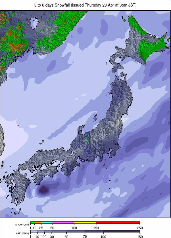
With the seasonal transition approaching, snowfall across Japan has begun to ease. There are still occasional decent dumps interspersed with sunny days, but base depths have stabilised after rapid growth earlier in the winter. Myoko’s Seki Onsen (610/610cm / 244/244″) continues to post the deepest snowpack in the world and remains the only resort currently reporting a base above five metres (200″). Most Japanese ski areas remain fully open.

Internationally renowned Niseko (210/295cm / 84/118″) recorded one of the largest snowfalls of the past week, receiving 45cm (18″) in 48 hours. Nearby Rusutsu also saw 40cm (16″) over the same period, indicating that while snowfall is reduced compared to January, it remains significant.
Conditions have been drier and milder across Honshu. Resorts in Nagano have seen afternoon temperatures rise to between 5°C and 10°C, with some rain reported at lower elevations instead of snowfall.
Japan Snow Forecast
A wintry but changeable pattern continues. In Hokkaido, upper slopes remain cold at –18°C to –8°C, with base temperatures between –12°C and –3°C. Light to moderate winds and periodic snow showers will maintain powder conditions. Further south on Honshu, temperatures vary more widely, from –14°C to –4°C on the mountains and –8°C to 4°C at base levels. Snowfall will be intermittent, with clearer spells alternating with bursts of fresh snow, particularly in northern regions.